Second Field Trip
February 7th, 2024
Introduction
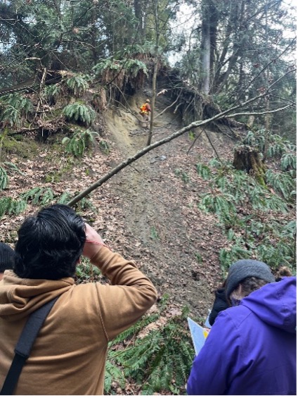
Under the supervision of Professor Tim Stokes, on February 7th 2024, students from the Environmental Geology class at Vancouver Island University examined slope stability issues at Sealand Park in North Nanaimo. During the fieldwork portion of the project, the daily temperature was 8 ℃ with a partly sunny sky. Groups of two to three students were formed with the goal to document relevant observations at sites of past or active landslides. Each group collected their own observations and developed a preliminary slope stability hazard map of the Sealand Gully and part of the shoreline. Features were located on topographic and LiDAR maps, placemark were saved in Avenza Maps (using a geo-referenced map) at each site of interest within the gully, soil samples were collected, and all observations documented into a field notebook. Once the fieldwork was completed the team developed a simple hazard map of Sealand Gully and part of its shoreline. Additionally, a simple risk analysis of the site accounting for potential impact to structures and properties was completed. The purpose of this field trip was to examine the possible causes of the landslides at Sealand Park, to identify sites with higher risk of future failures and better understand their impacts to infrastructures.
Background
Vancouver Island has an extensive glacial history with records of glaciation dating back to 194,000 years ago during the Penultimate. The latest glaciation is that of the Wisconsinian that occurred approximately 75,000 years ago. The Wisconsin Glaciation deposited a variety of sedimentary deposits including but not limited to glacial, glaciofluvial, lacustrine, and marine. These are defined lithostratigraphic deposits based on the means and climatic conditions in which they were deposited.
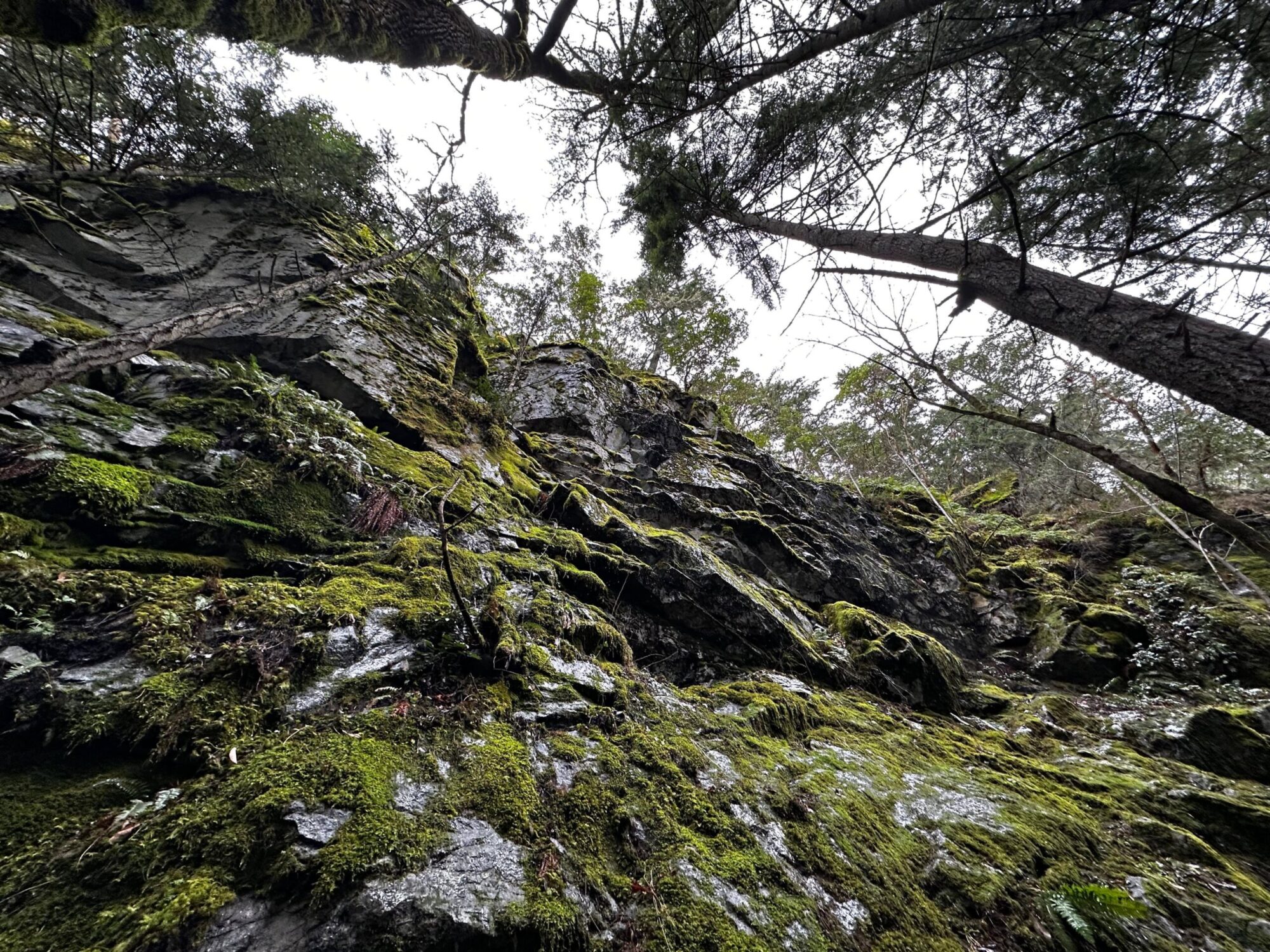
Sealand Park possessed thick deposits (tens of meter) consisting of Cowichan Head, Quadra Sand, Vashon drift and Capilano Sediments, and is situated within an existing gully that no longer possess an active stream channel and has been altered to such an extent that it is no longer viable for fish habitation. At the base of the gully an artificial pathway was constructed. The gully is exclusively cut through glacial material from the past flow path of the stream with the banks often presenting severe angles of repose. This degree is common given the composition of the deposits. Bedrock is not observable at the surface. The north-west extent of the park transitions into a high energy intertidal zone based on the large sized and well-rounded cobbles and boulders.
Notes and Observations
Table 1. Field Observations at Each Site at Sealand Park Gully.
| Site # | Dimensions | Slope | Slope Geometry | Volume of Debris Pile | Comments |
| 1 | Displaced Materials: ≈30 m length ✕ ≈4 m width ✕ ≈2 m thickSlope Length: ≈30 mHead Scarp Height: ≈20 m | 42° | Concave | ≈ 240㎥ | Shallow translation/ Earth fall/ Sparsely vegetated by ferns/J-hooked treesVashon drift underlain by Quadra sands. |
| 2 | Displaced Materials: ≈20 m length ✕ ≈10 m width ✕ ≈5 m thickSlope Length: ≈20 mHead Scarp Height: ≈50 m | 42° | Concave | ≈ 1000㎥ | Aged slump/ Middle-aged forest/ Slope sparsely vegetated with ferns/ J-hooked trees/ Overhang & head scarp with fresh fall to left/ Irregular slump. |
| 3 | Displaced Materials: ≈30 m length ✕ ≈60 m width ✕ ≈5 m thickSlope Length: ≈ 30 mHead Scarp Height: ≈38 m | 32° | Concave | ≈ 9000㎥ | Middle-aged forest with dense floor cover/ Irregular slope/ Unidentifiable failure mechanism due to vegetation/ Debris pile sparsely vegetated with ferns/ Head scarp inwards. |
| 4 | Displaced Materials: ≈ 30 m length ✕ ≈ 60 m width ✕ ≈ 5 m thickSlope Length: ≈ 30 mHead Scarp Height: ≈ 17 m | 31° | Concave | ≈ 9000㎥ | Earth fall/ Creep/ Possibly shallow translational/ Sparsely vegetated with ferns & middle-aged trees / Initial runout flat and regular that follows into irregular runout/ Middle-aged forest/ 40 horizontal / J-hooked trees at different directions/ Vertical head wall made of clay rich Vashon Drift(?) |
| 5 | Displaced Materials: ≈ 30 m length ✕ ≈ 20 m width ✕ ≈ 5 m thickSlope Length: ≈ 30 mHead Scarp Height: ≈ 40 m | 43° | Concave | ≈ 3000㎥ | Middle-aged forest with mature tree growth & sparsely vegetated ferns/ J-hooked trees/ Creep/ Irregular slope / Earth fall?/ Debris pile has regrowth on top/ Narrower comparatively |
| 6 | Displaced Materials: ≈ 15 m length ✕ ≈ 20 m width ✕ ≈ 5 m thickSlope Length: ≈ 15 mHead Scarp Height: ≈ 100 m | 28° | Concave | ≈ 1500㎥ | Vashon drift/ J-hooked trees/ Earth flow? Creep?/ Head wall with gradient Curved head scarp/ Fresh runout over vegetation / House up above on head wall/ Middle-aged forest & sparsely vegetated with ferns/ Regrowth on debris pile |
| 7 | Displaced Materials: ≈ 30 m length ✕ ≈ 3 m width ✕ ≈ 3 m thickSlope Length: ≈ 30 mHead Scarp Height: ≈ 10 m | 28° | Concave | ≈ 270㎥ | Overhanging head scarp (vertical) of Vashon drift (lenses and till)/ Runout irregular with recent colluvium and dead vegetation/ J-hooked trees/ Silt layer/ Regrowth on debris pile (middle-aged forest)/ Earthfall?Vashon Drift (lenses and till), silt layer within till |
| 8 | Displaced Materials: ≈ 15 m length ✕ ≈ 30 m width ✕ ≈ 3 m thickSlope Length: ≈ 15 mHead Scarp Height: ≈ 20 m | 40° | Concave | ≈ 1350㎥ | Earth flow /Debris flow fall with active creep and water flow on clay rich till(?)/ No observable head scarp/ Linear flow/ No translation/ Slight bowl shape/ Debris pile with regrowth (middle-aged forest)/ Sparsely vegetated with ferns/ J-hooked trees |
Table 2: Slope Stability Hazard Rating.
| Slope Stability Hazard Rating | Hazard Rating Probability/Likelihood | Descriptions of Slope Conditions |
| High | Probability of slope failure is eminent, and the magnitude could be considerable. | Evidence of natural landslide occurrence with a slope angle equal to or greater than 30 degrees. Urban development is within direct runout zone or proximal to head scarp. |
| Moderate | The probability of slope failure resulting in considerable mass movement of urban disturbance is not expectedwithin predictable parameters*, however, regular inspection is recommended. | Slope angle less than 30 degrees. Urban development is within vicinity. Poor to well-drained soils. Moderate gullying. Increased erosion expected following drainage disturbance. Water courses could cause higher potential of bank slumping. |
| Low | Probability of slope failure is unlikely, and magnitude is low unless extraneous conditions arise. | Slope angle is within 0 to 15 degrees. Poor to well drained soils. Minor slumping following ground disturbance |
Sealand Park Slope Stability Hazard Map
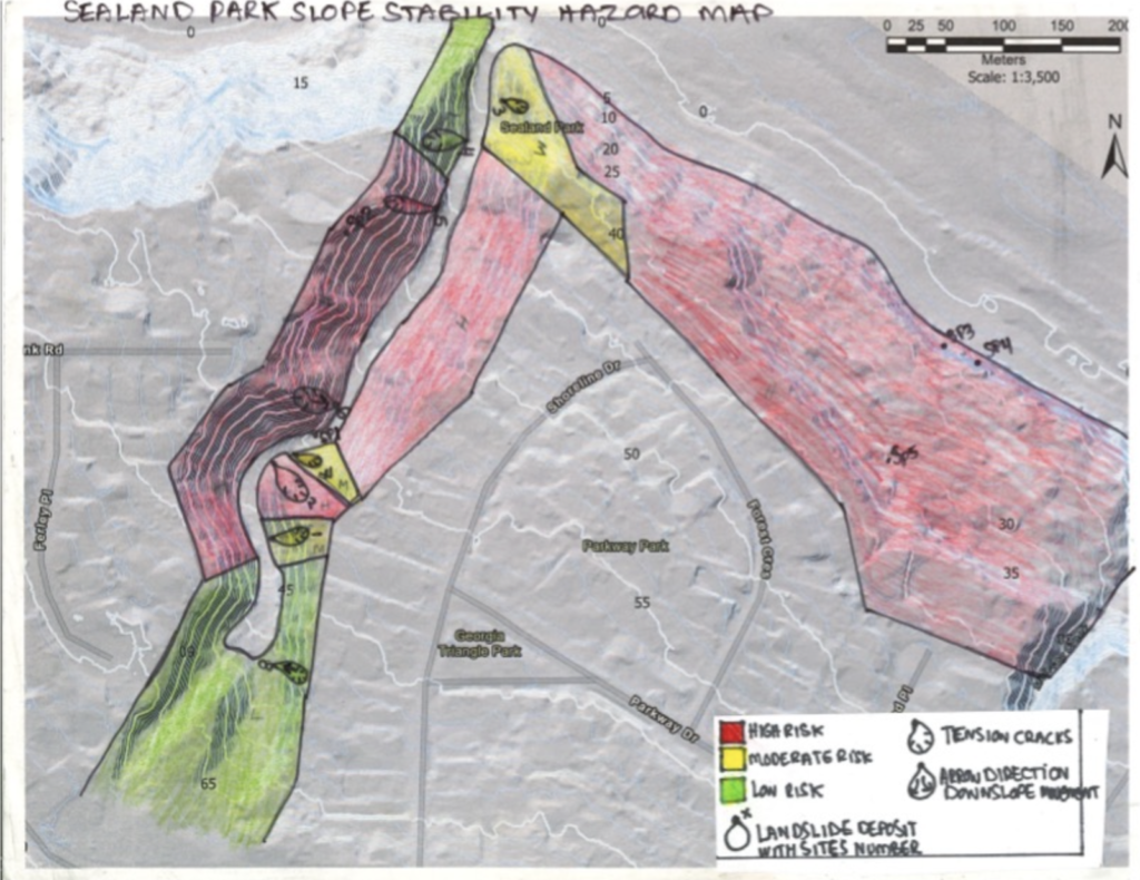
Figure 1. Sealand Park Slope Stability Hazard map, built by Fanny Deschenes and Aiden Kilcommons.
Conclusion and Recommendations
Risk analysis is based on in-situ site analysis, air photo interpretation, satellite imagery (Google Earth) in concordance with the existing knowledge and experience of the semi-qualified terrain specialists.
Within the area of interest (AOI) recent landslides are present providing an indication for the likelihood and magnitude of a subsequent mass wasting event. Air photos and satellite imagery provide comparison of historic conditions to present day. Knowledge and experience of terrain specialists can capture information from the former qualitative attributes to develop a rational for the terrain hazard rating. From the risk analysis completed at Sealand park, the following recommendations are proposed:
- Avoid undercutting steep slopes.
- No building near those slopes (base and top).
- Do not fill steep slopes.
- Re-vegetation of the gully banks.
- Installation of drainage systems.
- The drainage of large quantity of water should be avoid within the areas (draining pools, etc.)