Author: Jake Groot

Earth Science student from Smithers BC

A Little Glance at Lantz(ville)

Introduction

In this field trip we headed off to Lantzville to assess how properties on the shoreline were mitigating the effects of sea-level rise on their properties. This trip gave a lot of insite on the various methods used (both past and present) and the discussion of land-use planning on coastlines.

Background

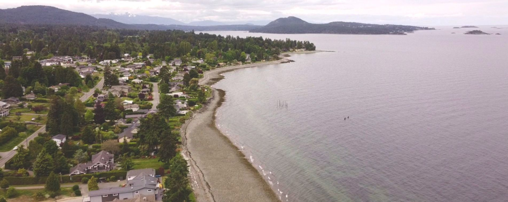
Lantzville is a small neighbourhood in the North of Nanaimo were many residences line the beaches. Many of these properties have been around for many decades and the rising sea levels and more occurence of storms have caused some issues in the area.

Drone photo over Lantzville (Retrieved from: nanaimoinformation.com)

The Trip

We hopped on the bus and headed North to Lantzville. We were disappointed with the fact that the expert on soft shorline protection was unable to attend. But luckily, we were led by the one and only Dr. Tim Stokes! We stared with a brief overview of the area then headed down to the beach. This was my first time there and it was real nice. I’d put a house down there for sure (using proper soft shoreline protection of course).

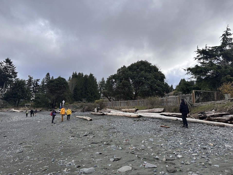
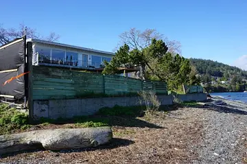
At the beach we were able to see the various kinds of mitigation practices that are in use. These practices varied from property to property. The first one we checked out was simply a 1 metre high concreate will with some pipes within for drainage. This one was not very appropriate as it caused a negative effect on the rest of the beach by altering sedimenet transport and natural ocean movments. It was also the most unsightly.

Class taking notes at the first mitigation technique spot.

The second, and most common method along the beach there in Lantzville was the use of boulders, logs, and other vegetation to create a more natural looking “wall”. This technique was the best looking in the area I’d say as it looked somewhat natural. When you took a closer look you could see that the logs were tied in to prevent them from moving during a high tide event.

A wide shot of the described mitigation technique above

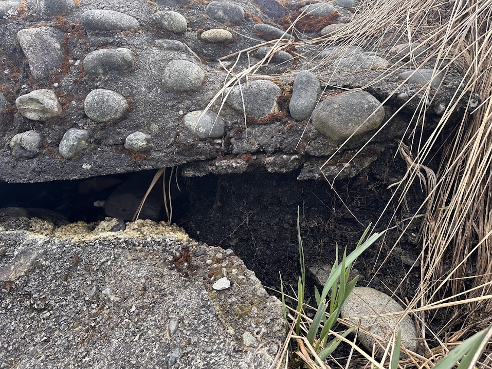
Another wall we saw was similar to the first one except it appeared more as a conglomerate style wall. This wall was heavily fractured and obvious signs of mending and reinforcing were seen. An interesting aspect of this one was the fact that it was resting on top of a layer of visible coal waste from past mining operations in the area.

Fractured wall with visible coal waste underlying.

On our way back out to the bus, we were stopped by a friend of a property owner on the beach. This man was very confusing and had a wierd sense of humour (he was most likely english of some sort). But apart from that he had a lot of information to tell us. He told us that in the past, property owners found kind of a loophole in the system in which they could infill into the shorline and therefore extent their property further out. The area in which the past high tide line occured actually lies right at the back doorstep of most residences. Ummmmm thats not good!

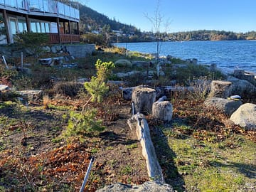
After the Lantzville portion of the trip we headed down to Pipers Lagoon to take a look at a green/soft shore project that occured there. This site was far different then what was seen in the North. In consisted of a larger buffer zone (roughly 6 metres deep) that was full of rocks, stumps, logs, and native plants that are acustom to periods of time in the presence of ocean water. Along with the beach side of the property undergoing some change, the paved driveway was also replaced by pervious gravel to improve site drainage.

Pipers lagoon site before greenshore project.
Pipers Lagoon site after green shore project.

Conclusion

This trip provided a lot of insight into shorline protection of the past and the future. It allowed us to see how construction of certain features may benefit homeowners temporarily, but overall nature will overcome those features and therefore create further problems. The ultimate way appears to use green/soft shore practices to allow for natural high tide processes.

References

Lil’ Intro: What I know about Environmental Problems

(This blog will be written in the perspective of myself on January 7th, 2024 when I had not learned any course material on the subject of Environmental Geology)

Understanding of Environmental Problems

Basically an environmental problem is when something from the environment disturbs other aspects in a negative way. Such as the following:

  • A landslide that cuts off bodies of water.
  • Earthquake causing a fault.
  • Water running over rocks that may produce acid rock drainage.

These problems can vary in size and hazard, and affect some things differently than others.

Why are they complex?

They are complex because they have various factors such as social, economic, political, geological, and biological domains in which a change in one of these aspects could trigger effects across all of them. Human activities such as urbanization and resource extraction have caused some bad effects on the environment such as slope instability from forestry practices, and dangerous runoff entering creak systems disrupting the ecosystem.

How can Environmental Geology aid these problems?

Environmental geoscientists can contribute many ways in the reduction of thse problems. These ways include:

  • Assessment of Hazards: assessing probability and scale of landslides, earthquakes, floods, and volcanic eruptions.
  • Hydrology/Hydrogeology: learn how water systems flow in specific areas and design systems to protect the natural state of the system and the habitat.
  • Land use planning: understanding of how underlying geology suits specific needes for infastructure or urban areas.
  • Natural Resource Management: assess the availability and sustainability of natural resources.

Dump n’ Chase: A look into Nanaimo’s Waste Management

Background

The landfill is believed to have began as a former open pit coal mine which waste was dumped into around the 1930’s cause “hey! we gotta big hole in the ground now, may as well fill it with something”. Dumping of various waste types continued until the regional district of Nanaimo purchased the land and continued operation.

Aerial image of the site (2016)

Nanaimo’s SWMP

The Regional District of Nanaimo oversees solid waste management and has set a goal to reduce landfill waste by 90% by 2029. The City of Nanaimo plans to implement various programs aimed at waste reduction. These initiatives include; zero waste education, household hazardous waste collection, managing industrial, commercial, and institutional waste more effectively, improving construction waste management, licensing waste haulers to incentivize diversion over disposal, and investing in zero waste recycling research and facilities. Through these efforts, Nanaimo residents, businesses, and institutions are encouraged to participate actively in waste reduction to achieve the region’s solid waste management goals.

Field Trip

The field trip occured on Wednesday, March 13th on a beautiful sunny day. The possibilty for the smell of steaming garbage was heavy on the minds for all classmates. But once we arrived at the landfill those thoughts were put to ease as it actually didnt smell too bad at all. We were met at the front office by Chad, a p.geo who monitors the leachate and contamination levels around the site. Chad got his degree at the University of Saskatchewan in geology, he then moved from various exploration companies until he slowy got more involved in the environmental side of geology. At the front office parking lot, Chad gave us a nice debrief on the ins and outs of the landfill. We learned that the RDN landfill collects around 60,000 tonnes of garbage a year, which comes around to about 500 cubic metres per hour.

We then took the bus on drove through the site. We stopped near the methane burn stack and discussed methane collection at the site. The site consits of 50 vertical and 20 horizontal wells that “vacuum” out the emitted gases. The horizontal wells are more efficient however harder to place compared to vertical wells. The methane is currently collected and flared in order to convert methane to carbon dioxide which is a less harmful greenhouse gas. The methane used to be collected and converted to energy by a private company however it was not a profitable company. Fortis BC however is thinking of attempting to hook into the system and convert the methane to energy.

Methane Flare

We continued up the hill and looked at a shredder that was in a pilot program where they would grind up the garbage before laying it down. This allowed the garbage to be put into the landfill at a higher density than normal which is important because the site has a finite “air space” in terms of slope and parcel size. This then extends the life of the site by allowing more garbage to be packed into the hill. This method is especially usefull on large items such as mattress or couches, both of which have a habit of continually pushing to the surface even when it is packed many times by a trash compactor.

Un-operational shredder

Continuing up the hill, we stopped at the top to watch the landfill operator process. It was actually quite the process! A good density of around 4 machines working to complete different tasks. A front loader would scoop up garbage, drop it infront of the trash compactor then back up and let the compactor skim over the top and compact the garbage in around 5 passes. The trash compactor is a 80 tonne machine and its actually the large spiked wheels that do the majority of the work. The machines had to work carefully as there was a methane well pipe sticking up at surface. To the right of the operation there were about 4 very large metal “platforms”. These platforms are used to go on top of the garbage when work has halted in order to prevent birds from getting in there and also reduces amount of rainwater that enters the garbage. More water in the material leads to more leachate.

Bus of students looking at the trash compactor at work

We wrapped up by heading down to the bird coops to check out a harris’ hawk. A bird like this is used to scare away the birds from site. They do this in order to prevent birds ingesting the garbage and spreading the garbage around the local area if they fly away with it.

Harris’ Hawk

Conclusion

The RDN is about to invest a sizeable amount of money for a consultant to find them an area in the district that would suffice for the next site of a landfill. Because they only have around 15 years of life on the current site, they need to start thinking of the future. A big discussion with siting a new landfill is the thought of NIMBY (Not in my backyard). Chad argues that having many small landfills is the most effiecent and eco-friendly (assuming humans still consume a lot). This is based off emissions for transport and it allows people to become more involved in where there waste goes and how it gets processed.

Overall this was a great field trip and it definitly opened my eyes to how I view my waste and how my waste effects the environment.

Boxing with Past Mistakes on Boxwood Road

Introduction

2229 Boxwood Rd is an 8.5 hectare property located in central Nanaimo near Beban Park. It is currently being developed as a low density residential area. Although development seems simple with regards to topograpahy and local opinion, it has actually been quite the hardship. The lot is full of mining and construction waste which proved to be difficult to navigate, therefore the plot has switched possesion many times. The purpose of this lab was to conduct an Environmental Site Assement as if it were 2017 and no remediation had occured yet. To do this, each team did a historical review as well as a field survey to determine the issues associated with this property.

2017 Satellite image of 2229 Boxwood Road

Background

The first recorded human use of this property was as a part of the Northfield Coal Mine which was operational from 1889-1895 and later used by the Wellington Mine. The coal waste from operations on this site are still present today as well as an adit and a shaft (both of which have been deactivated). A lake was also present on this propery around 1930-1985, which was in-filled by various debris from projects nearby.

Air photo from 1958 showing body of water that was later in-filled.
1972 image showing the body of water being filled in.

Phases of ESA’s

Phase 1: Non-Intrusive Historical Review

Conducting a historical investigation, site reconnaissance, and preparing a document of findings and conclusions. Some records to review are:

  • Aerial photography and satellite imagery
  • Water wells and climate information
  • City directories and Site Registry
  • Geologic information
  • Municipal Files and Archives

Phase 2: Intrusive Site Investigation

If Phase 1 results in the determination that the site has a chance of contamination, then Phase 2 is put into motion. This phase could result in surficial and sub-surface soil sampling, groundwater, and surface water sampling. These results are then compared to CSR standards, if samples are determined safe then no further work is needed. If samples are above the standards then site must move on to Phase 3, where delineating, quantify, and calculating volumes occurs.

Phase 3: Remediation

Once estimations on remediation extent are determined, then remediation is undertaken. Remediation varies from site to site, but results in safe environmental conditions.

Field Trip

On Wednesday, March 6, the GEOL312 class joined Roxanne Croxalle from Tetra Tech to take a little tour of 2229 Boxwood Road. This was a very informative trip and lots of aspects on the property were discussed. We started the tour in the North end then worked our way through the property. The North end consisted of a remediated section where surface soil which was contaminated with coal and construction waste, was stripped at a level around 1.5 m below surface. Roxanne let us know that the soil in this area was clean enough to where you could basically eat it without safety concerns. We then headed are way to the centre of the property where a large mound sits. This mound is actually 32,000 cubic metres of coal waste covered with an extremely compact 1 m deep layer of soil. This mound has a coventent on it (no moving or building on it) as well as acts as a sound barrier for a future roundabout planned just Southeast of the planned residences.

Senior VIU student Brayden Klassen posing in front of the remediation mound that covers 32,000 cubic metres of coal mining waste.
Image from the top of the mound looking North which displays the professional landscaped hill side full of native species.

Conclusion

This lab provided the class with insight on the behind-the-scenes of development of project sites in the district of Nanaimo. Roxanne was a wonderful educator into life as a geoscientist in this field and gave us a great tour of the property. It was very nice to see how much weight local and federal governments put onto remediation of properties where past human activites have environmentally altered the landscape. It is wierd to think of a time where waste was simply dumped in empty lots without consideration. Anyway, good lab and heres to a clean future!

Departure Bay Restoration Project – For the Fishies!

Introduction

On Wednesday February 28, the GEOL312 class braved the harsh weather conditions to learn about a creek restoration project in Departure Bay area. The creek in question is the Departure Bay Creek. This creek winds its way through the residential neighbourhoods of the bay area and his home to many fish species such as coho, pink, chum, and steelhead. This water system has gone through the ringer since colonialism of the area, but the volunteer Streamkeepers are working hard to allow this stream to function properly as a habitat for the local fish species.

Background

The Departure Bay Creek in the past was a beautifully intricate natural creek that winded through humungous old growth cedars end entered the ocean as a marshy wetland that provided habitat and nutrients to many species. When colonialism came to the island this natural habitat was destroyed. Trees were harvested, the creek was redirected, and the wetland was drained and covered. Because of this, the habitat that the creek provided was almost completely destroyed. But luckily, over the past couple decades, a passionate group of volunteers have worked hard to restore what they can and create new possibilities for fish and other species.

An image of old growth forest on Vancouver Island. This image represents the landscape that surrounded Departure Bay Creek before colonialization.

Problems

The problems associated with the Departure Bay Creek revolve mostly around fish and their early life cycle. Listed below are issue that the past creek system had with regards to fish habitat.

  • High sand sediment content: High levels of sand within the stream cause problems with Alevin due to them being unable to swim up through the sediments to get to the main stream flow. The sand in the stream is from an erroding glaciofluvial embankement upstream.
  • Pollution: Nearby residences and roads allow for the transport of unfriendly pollutants. One new prominent pollutant is from degrading car tires, its called 6-PDDQ, and even low concentrations can be deadly to fish species.
  • Aggressive Channeling: Past channeling created a consitent fast moving creek that did not allow fish to easily rest or reproduce.

Restoration

First nations groups, local government, and non-profit organizations have come together to resolve habitat issues at departure bay by implementing many different methods.

  • Creation of Pools: pools allow fish to rest as well as allows organic debris and suspended sediment to settle.
  • Oxygenation of Water: inclusions of small weirs in the stream bed increase levels of oxygen in water by essentially creating bubbles.
  • Plantation of Native Species
  • Addition of 2nd Channel: a small second channel was created to add other areas of habitat for small juvenille salmon. This channel has a much slower flow rate as well as more vegetation and cover which allows for salmon to hide from predators if need be.
  • Bed Material: cobble sized rocks were placed in strategic areas of the creek in order to alter stream dynamics.
Man-made weir providing oxygenated water.
Pooling near culvert
Image of channel realignment construction.
Construction of new side channel.

Conclusion

Departure Bay Creek is a great example of the level of care that should be placed on every creek or stream system. In the past, streams were seen as simply the movement of water, this movement could therefore be altered to fit the needs of the people in any way they saw fit. Today, the understanding that a stream is a dynamic system that provides habitat to many important species is being brought to the public through volunteers and non-profit organizations.

Sebastien.

Colliery Dam Field Excursion

Intro

The purpose of this field trip was to learn about and assess a real-life environmental issue that is occurring just a short walk away from VIU. In the field, we met Ewan and Mike from the regional district of Nanaimo who gave us an in-depth tour of the local park as well as background information into the logistics behind adaptation of areas with environmental concerns. The tour began in the parking lot near the lower dam where we discussed the park as a whole as well as the issues that were faced during the large rain event that occured in 2021. We then meandered our way up to the middle dam where evidence of flood water damage could be seen on the spillway.

Background

The Colliery Dam Park conists of three man-made lakes (ie. reserviors) that were created in 1910 and used as in coal mining practices. In the 1970’s, the site was turned into a park and is enjoyed by many locals as an area to walk their dogs or take a nice little dip when the weather is nice. I consider myself one of those individuals, during the summer I have spent many days lounging on the shoreline and taking lil dips to cool off (water quality might be a lil issue but whatever… I’ll live).

In the past decade, more care has been taken to assure saftey to the nearby community in the event of catastrophe. Recently, analysis of the Colliery Dams by the provincial gonvernment unveiled the danger of these structures. It was found that there is a high vulnerabilty of dam failure as well as very high downstream consequences. These two factors made this site one of the most at risk dam sits in the whole province.

View of Colliery Dam Park

Observations

  • The dams were created in the early 1900’s and are of relatively unkown composition, most likely sediments such as clays and mine waste rock. The composition of the dams is what creates such a high risk for dam failure. Drill testing is planned in the near future to determine the make up of the dams.
  • The flooding event of November 2021, provided the city with insight on how the site will react to heavy precipitation. In the lower dam, the one at most risk of effecting the community, there are 2 spillways as well as a new diverging channel. The newest spillway is in the shape of a W, rather than a curve, in order to increase surface area which allows more water to effictively evacuate the system. Overall, the spillways managed the water relatively well and the possibilty of over topping was mitigated.
Image of lower dam spillway.
  • The talk of reservoirs led to the discussion about the water inventory of Nanaimo. It was revealed the Nanaimo has very abundant water resources around the city in the form of other lakes such as Westwood Lake. According to calculations, the resource should suffice until 2050 (I think that was the stat). However, nearby communities may be in need of water from the community if drought conditions continue to affect the province (which they most likely will).
  • With Ewan and Mike working for the District of Nanaimo, we got an inside look into regulations, as well as community engagement. In this case, the community had a very strong opinion on what they wanted the outcome to be. The communtiy valued the recreation site and believed it should remain the same due to it “always being like that”. Basically the city had three options: take down the dams and restore the creek to its natural state (safest route), re-engineer the dams to make them safe if an earthquake occured (most expensive), or to leave it as is with ongoing mitigation and assesment (riskiest). In the end, the district decided on the last option.
Brock Palmer, a fellow VIU student, displaying two fingers to show how many lakes there are in the park (he can’t count, there are actually three).

Conclusion

This field trip was a great introduction into the field of environmental geology as it provided insight into local issues that are relevent to us. Mike and Ewan were very in-depth and passionate about the in’s and out’s of what goes on during environmental hazard decisions. Learning about how much the communities ideas affect a decision was really eye opening to me, as it shows how environmental decisions aren’t always based on pure science but rather cost and public opionion as well.

Powered by WordPress & Theme by Anders Norén