Field Trip 4: Environmental Site Assessment at Boxwood Road
Introduction
On March 6, 2024, the class of Geol 312 participated in an Environmental Site Assessment at Boxwood Road at a new residential development site. At the site, we met with Roxanne, the GIT who works with Tetra Teck. This property has been Roxanne’s project for the last few years and she’s been involved in the remediation process throughout. This field trip highlighted the importance of environmental remediation, contaminated sites, as well as explained the process of Environmental Site Assessments (ESAs). Roxanne has been working on this site since 2019 when there was a development proposal. Once the development proposal was accepted, it was then that Tetra Teck was hired to assess the property and ensure it was up to government standards.
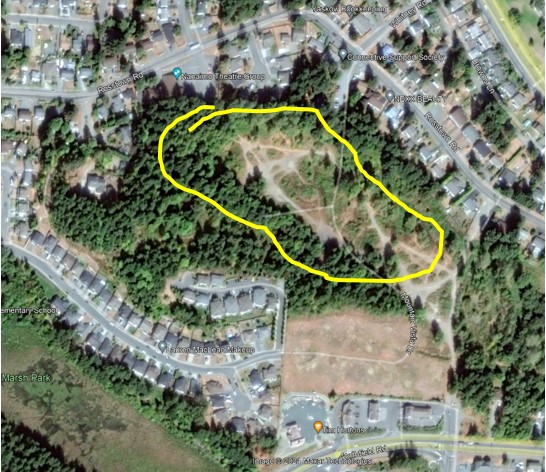
Figure 1: The area circled in yellow is 2229 Boxwood Road, where the ESA took place.
Background Information
In the late 1800’s to early 1900’s, Brechin Mine, also called No. 4 Northfield Mine was in operation in this area of Nanaimo. According to Nanaimo Heritage Tours, Coal Mining in Nanaimo, this area mined the Wellington Seam. This seam was originally discovered by Robert Dunsmuir at Diver Lake and opened Shaft Nos. 1 through 6 from 1882-1900. 2229 Boxwood Road is circled in yellow in the image below. At the Boxwood site, the adit and shaft are still there. However, they are both filled in and do not allow public access. In fact, the old coal cart tracks were even found.
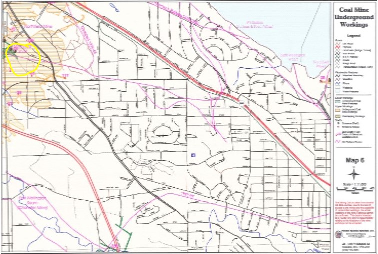
Figure 2: Coal Mine Underground Workings Map from Coal Mine Underground Workings Atlas. The area circled in yellow is the property under assessment.
Boxwood Road before the 1970’s had a small lake and was covered in a forest. In Figure 3 below, a photo taken in 1958 can be seen of Boxwood Road with this lake. I don’t quite understand the timeline of events, as it would be thought the miners would fill in the lake with mining waste prior to 1958, however, it could be possible this spot was mined after, or there was a different fate to this lake. What I do know is Boxwood Road was littered with mining waste, coal waste, and construction waste by the time development was proposed in 2019 and the lake is gone today.
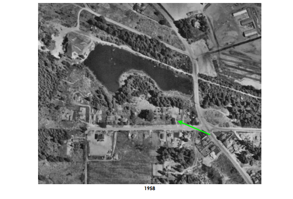
Figure 3: Boxwood Road in 1958. The green arrow is the site under investigation, with the lake north of it.
Site Visit Overview
Prior to the developmental proposal, Boxwood Road was a wooded area with trails for public use. Once Tetra Teck was hired, they discovered tons of coal waste, mining waste, and construction waste in layers covering the property. Roxanne explained that the coal waste and mining waste was underneath the construction waste. It is likely from the early 1900s and contained low-high grade coal, and overburden consisting of red/pink shale, which was high in arsenic. The construction waste is thought to be from the 1950s-1980s and consisted of car parts, treated timber, concrete/pavement, and an assortment of contaminated soils. Roxanne said when they began here, they were able to spot the areas of disturbed soils where the cottonwood trees were growing. I believe this is because they tend to grow with shallow roots so wouldn’t mind the bad soil, whereas Douglas Firs, Cedars, and Maples likely wouldn’t prosper in these spots. Most of the soils on the property contained arsenic, benzine, cadmium, and other heavy metals.
The North portion of the property was remediated when we visited to a numerical value. It was all excavated and replaced with ‘good’ soils, which means it is safe for humans to play in/plant in. The central part of the property, lot 5 in particular, still contains traces of iron, magnesium, and lithium which means homeowners/renters will have to have raised garden beds and no water wells can be dug here. In the South portion of the property, there is an artificial ‘hill’, about 10m high, with a 1m ‘safe’ soil cap on top. This hill is built up of contaminated waste (except for the top 1m), with a trail on top. This mound also doubles as a noise buffer from traffic nose for future homeowners/renters. Along the slopes of the mound are logs from the property that are in place to stop/slow the movement of water and debris. There are restrictions and it is not possible to build on the hill.
There is a portion of the forest that was kept, perhaps to be saved for future property development, but hopefully, it will stay a forest. In this forest, there is no more coal waste or construction waste, as Tetra Teck also cleaned this area out.
On the property, there is 1 monitoring well near the former coal mine shaft and adit. This well is to monitor the groundwater for heavy metals or other contaminants.
When we visited, in some areas of the property there was still coal waste present. These spots do not contain ‘that bad’ of contaminants and will be capped with ‘good’ soil eventually.
Overall, 32,000 cubic meters of mixed waste were dealt with here for the safety of the environment and future inhabitants.
Concluding Comments
Overall, I found my experience at Boxwood Road and the process of ESA’s very interesting and helpful. I find the stream of environmental work within geology very rewarding and can see myself doing it one day. Understanding the process from start to finish was very interesting and must be very rewarding for Roxanne to see her hard work paying off there. Also, learning bits about the mining history of Nanaimo and how the landscape has changed so much is very interesting.
References
Priest, S. (n.d.). Coal Mining in Nanaimo. http://simonpriest.altervista.org/HERITAGE/Coal.pdf
Lindsay, S. (2004). Coal Mine Underground Workings Atlas.