Field Trip 1: Colliery Dam
Introduction
On Wednesday, January 10th, 2024, the class of Geol 312 braved a cold, dry (yet sunny) winter day to learn about a local historical park, near the Vancouver Island University. The class all met at Colliery Dam’s main parking lot, which is a few blocks south of VIU. This park is made up of the Middle and Lower Chase River Dams located on the Chase River in the southern half of Nanaimo. We met with Mike Squire and his colleague, Euan Wilson here for a tour. Mike and Euan work for the City of Nanaimo within the Water Resource sector. Mike happens to be the Manager of this department as well. The main purpose of this field trip was to gather information and learn about a real-life environmental issue, so as Mike and Euan described what has been going on at Colliery Dam for the past 10 years, it was eye-opening. This park I took for granted for the years I’ve lived in Nanaimo was actually a massive risk to livelihood but also carried a lot of history with it.
The Colliery Dam Breach Issue was brought into focus in 2011, following a dam failure in the Okanagan in 2010 – the Testalinden Dam. This dam breach occurred in a historic region, south of Oliver, BC in which homes and livelihoods were destroyed by the debris flow. The result of such an event naturally brings up questions and concerns for other areas, and this is what happened to Colliery Dam and the investigation into the hazards surrounding the two 100-year-old dams. Following the inspections of Colliery Dam, it was found that the dams held a very high probability of dam failure with very serious consequences downstream.
Background Information
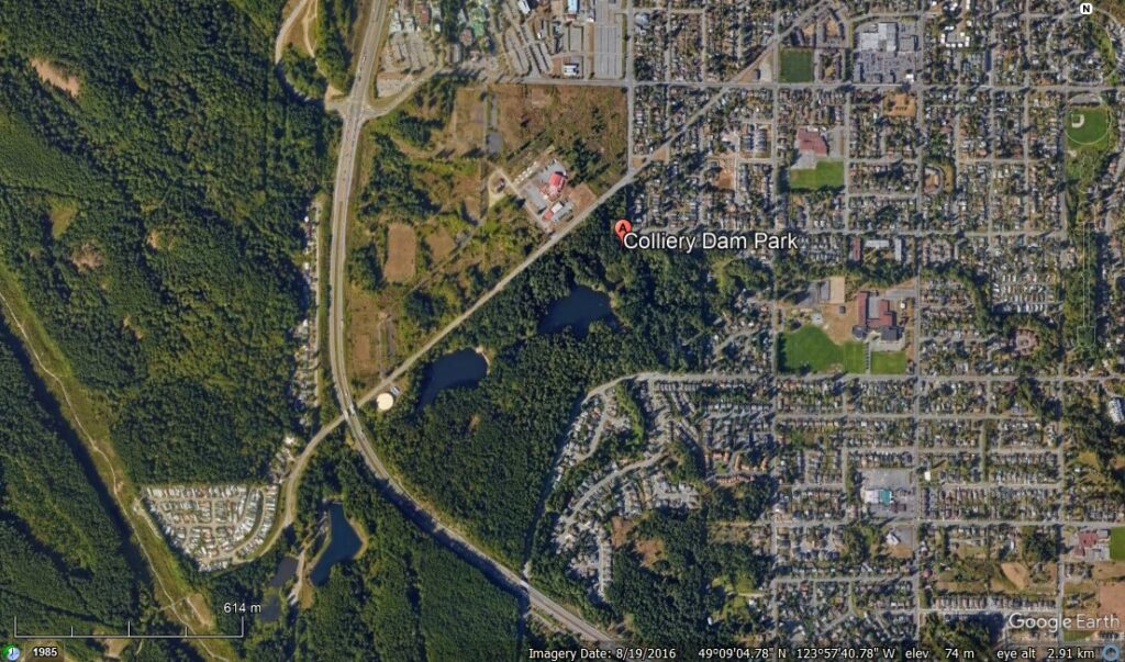
Colliery Dam was built in 1910-11 by the Western Fuel Company as a place to wash coal. It was also used by the miners, mules, and horses in the mines, and as a water line to nearby homes. The water system was eventually carried to most South Harewood homes until another dam was built in 1932. The dams at this park are a rare link to Nanaimo’s industrial and coal mining heritage, and as of 2002, recognized and registered as one of Canada’s Historic Places (Vancouver Island Views, 2023). The park is made up of 2 dams, the Middle and Lower dams. These dams are what the park is centered around. This can be seen in Figure 1 below.
The dams are underlain by the Nanaimo Group Sediments, which outcrops of sandstone are seen throughout the park. Locals familiar with the park state there are caves in “clusters of large rock formations that were formed during the Ice Age” (Bob, n.d.). Interestingly, there is a fault that runs directly through the dams. Thankfully, this fault isn’t considered active, but that doesn’t mean it never will be.
Site Visit Overview
During the visit to Colliery Dam Mike, and Euan had many interesting notes about the history of the park, the process of the past 10 years, as well as the next steps. When the dams were built, the builders didn’t take note of the materials being used to build them, which seems about right for it being 1910 and all. However, this puts engineers into a pickle today, as the materials used to build it have a large impact on the stability and risk assessment of the dams and it’s not as easy as drilling into them- as this could cause many more problems.
As mentioned, in 2010 when the dam breach in the Okanagan, it caused a domino effect of dams around the province being heavily investigated and scrutinized. The dams at Colliery Dam Park were assessed to be at an extremely high risk of breaching. These results gave the City a few options on how to proceed, but something clearly needed to be done. The 2012 Chase River Dam Breach Flood Inundation Study Report states, these approaches were:
-Complete removal of the dams.
-Partial mitigation of risk factors and acceptance of a higher degree of risk by the City’s
stakeholders.
-Extensive mitigation of risk factors to bring them into compliance with the BC Dam Safety
Regulation and Canadian Dam Association’s Dam Safety Guidelines.
From what we heard from Mike and Euan, the first approach was not acceptable to the Nanaimo residents and protests ensued over the possibility. Therefore, the city chose the options of least violence and has been continuously working on the Dams and mitigating any risks that may occur. As Vancouver Island is at a high risk of extreme precipitation as we saw a couple of years ago with the atmospheric river of 2021, high risk of large earthquakes, referred to as ‘the big one’, which is ‘coming any day’, not to mention these dams are over 100 years old.
If the dams do breach, there are considerable consequences. The area downstream from the dams, which encroach onto Chase River includes growing residential areas, a high school, daycares, and, major roads, and highways. This area is littered with people at all times of the day who would undoubtedly be affected by a breach.
Concluding Comments
Overall, I found my experience at Colliery Dam very valuable. I had no prior knowledge of how much time, energy, and money have gone into the dams and the park, the risks they pose, and the politics that surround it all. As a local who lives near Colliery Dam, it makes me a bit nervous for my safety and I may have traced how close I am to the expected floodplains- but it also made me realize how much I take the Park for granted. It is such an interesting part of Nanaimo’s history and it clearly has a very big impact on the residents who saved it from destruction, whether that is good or not.
Mike and Euan mentioned this year is the 10-year review of the mitigation work done here and I’m looking forward to following along and learning about the next steps for this area.
References
Parcher, Kim. 2023. Nanaimo’s Colliery Dam Park: A Historic Treasure. Vancouver Island Treasures. Retrieved from https://vancouverislandview.com/colliery-dam-park-in-nanaimo/.
Bob, n.d. Discover the Beauty of Colliery Dam Park and Granny Falls. Who Said Photography: Photo Adventures with Bob. Retrieved from https://whosaidphotography.com/colliery-dam-park-granny-falls-nanaimo/.
Chase River Dam Breach Flood Inundation Study Report. (2012). Retrieved from https://www.nanaimo.ca/docs/your-government/projects/2015-colliery/report-37.pdf.